Plate Tectonics debunked

Stripe

Teenage Adaptive Ninja Turtle
LIFETIME MEMBER
Hall of Fame
Plate Tectonics explained

The convection idea presented in this video is bunk.

At atmospheric pressure, rock melts producing magma that is less dense than its parent material. However, at pressures found quite near the surface (about 400km, depending on type), rock that melts produces magma that is more dense than its parent material.

This means that there is a crossover depth above which melted rock will rise and below which melted rock will only ever sink. Thus convection of the mantle cannot happen.

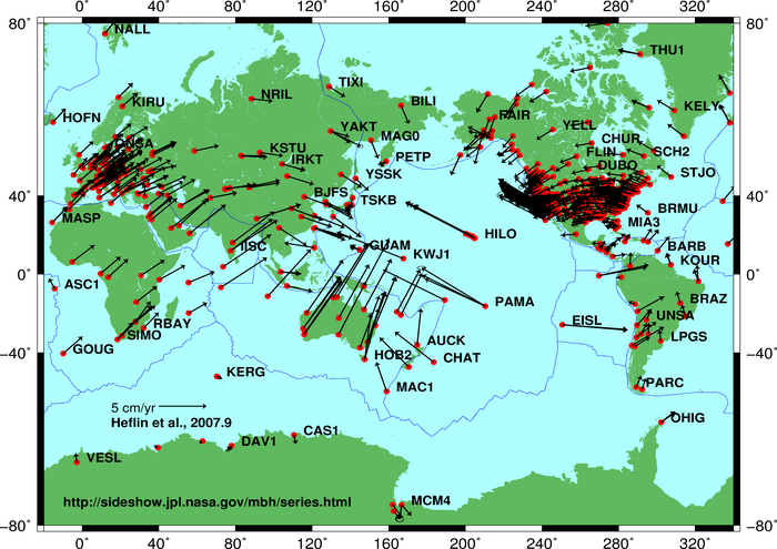
Also, GPS measurements do not measure crustal movement of the type described. The data comes from movement due to earthquakes, not the steady, slow drift predicted by plate tectonic theory. The mid ocean ridge is accessible on land in some places, but laser measurements between the two edges do not show the drift.

The explanation for the surface features is understandable with a rejection of the assumptions presented in this video and a simple model of gravity producing friction, producing melting, producing a denser and shrinking core.

This means that the volume of the Earth is shrinking.
 
Last edited:

Jose Fly

New member
So should we tally up what True Christians at ToL must believe?

The universe is less than 10,000 years old.

The earth is less than 10,000 years old.

The entire universe orbits the earth.

The earth does not move at all.

Plate tectonics is false.

The entire earth was flooded ~4,000 years ago.

All life was reduced to 2-7 individuals of each "kind" ~4,000 years ago.

Humanity was reduced to 8 people ~4,000 years ago.

All life was created according to "kinds", which no one can define.


Sheesh....no wonder Christianity is dropping like a rock and young people are leaving in droves.
 

Nazaroo

New member
Plate Tectonics explained

The convection idea presented in this video is bunk.

At atmospheric pressure, rock melts producing magma that is less dense than its parent material. However, at pressures found quite near the surface (about 400km, depending on type), rock that melts produces magma that is more dense than its parent material.

This means that there is a crossover depth above which melted rock will rise and below which melted rock will only ever sink. Thus convection of the mantle cannot happen.

Also, GPS measurements do not measure crustal movement of the type described. The data comes from movement due to earthquakes, not the steady, slow drift predicted by plate tectonic theory. The mid ocean ridge is accessible on land in some places, but laser measurements between the two edges do not show the drift.

The explanation for the surface features is understandable with a rejection of the assumptions presented in this video and a simple model of gravity producing friction, producing melting, producing a denser and shrinking core meaning the surface is subsiding.

Thanks for the thoughtful discussion and additional scientific data.

Keep up the good work
 

Stripe

Teenage Adaptive Ninja Turtle
LIFETIME MEMBER
Hall of Fame
Iceland.
Spoiler
Iceland_-_Thingvellir_36_-_plate_boundary_fault_line_(6571229459).jpg

If you put a laser measuring instrument across that divide, the only time you'll register any change is when there is an earthquake.
 

Eeset

.
LIFETIME MEMBER
Iceland.

If you put a laser measuring instrument across that divide, the only time you'll register any change is when there is an earthquake.
Thanks. But when I go to google earth I can see the mid oceanic ridge and it doesn't seem to extend to Iceland. I'm not disputing your basic premise. But I am interested in learning more.
 

Preceptive

New member
Are there articles or videos from geologists explaining that principle and showing where this "crossover depth" is?
 

Eeset

.
LIFETIME MEMBER
I use Google Maps. You can see where the ridge comes ashore here. Being on land, it is readily eroded so not as obvious as it is on the seafloor.
Thank you. I brought those coordinates up on Google earth as opposed to google maps and there you can see quite clearly that your location is north of the mid oceanic ridge.

I did find a good article for you. It took me a little time to read since it is 145 pages long. It includes measurements of various sections of the ridges and rates of expansion. http://www.dynamicearth.de/Lectures/Geodynamik.WiSe09/Vorlesung/extra8.pdf
 

NathanM

New member
Wow - you have totally overturned a major principle in geology. When do you plan to present this earth-shattering (no pun intended) research to the geological community? I'm sure that they will want to start employing Garmins in their research.
 

Stripe

Teenage Adaptive Ninja Turtle
LIFETIME MEMBER
Hall of Fame
Wow - you have totally overturned a major principle in geology. When do you plan to present this earth-shattering (no pun intended) research to the geological community?
I just did, you moron. :loser:
 

User Name

Greatest poster ever
Banned
GPS measurements do not measure crustal movement of the type described. The data comes from movement due to earthquakes, not the steady, slow drift predicted by plate tectonic theory.

What can GPS tell us about future earthquakes?


GPS stations along the coast of Japan had been moving to the west before the March 11, 2011 earthquake, and rebounded back to the east following the earthquake. This animation compares that subduction zone with a mirror-image subduction zone in the Pacific northwest by illustrating how the shallow portion of the Cascadia plate boundary is locked by friction thus compressing the overlying North American Plate in a NE direction during subduction of the Juan de Fuca Plate. Using a spring to emphasize the strain within the overlying plate, we will see the displacements of GPS receivers along the entire leading edge of the North America continental margin. Ultimately, the continental margin will rebound suddenly to the southwest as the stored elastic energy is released for the first time since the last great Cascadia earthquake on January 26, 1700.


User Name

Greatest poster ever
Banned
Current plate movement can be tracked directly by means
of space-based geodetic measurements; geodesy is the
science of the size and shape of the Earth. Because plate
motions are global in scale, they are best measured by
satellite-based methods. The late 1970s witnessed the rapid
growth of space geodesy, a term applied to space-based
techniques for taking precise, repeated measurements of
carefully chosen points on the Earth’s surface separated
by hundreds to thousands of kilometers. The Global
Positioning System (GPS) has been the most useful for
studying the Earth’s crustal movements.
By repeatedly measuring distances between specific
points, geologists can determine the movement along
faults or between plates. The separations between GPS
sites are already being measured regularly around the
Pacific basin. By monitoring the interaction between the
Pacific Plate and the surrounding mostly continental plates,
scientists are learning more about events that build up
to earthquakes and volcanic eruptions in the circum-
Pacific “Ring of Fire”. Space-geodetic data have
already confirmed that the rates and directions of plate
movements, averaged over several years, compare well
with rates and directions of plate movements averaged
over millions of years.​

Source: http://www.iris.edu/hq/files/programs/education_and_outreach/aotm/14/1.GPS_Background.pdf
 

Stripe

Teenage Adaptive Ninja Turtle
LIFETIME MEMBER
Hall of Fame
Current plate movement can be tracked directly by means
of space-based geodetic measurements; geodesy is the
science of the size and shape of the Earth. Because plate
motions are global in scale, they are best measured by
satellite-based methods. The late 1970s witnessed the rapid
growth of space geodesy, a term applied to space-based
techniques for taking precise, repeated measurements of
carefully chosen points on the Earth’s surface separated
by hundreds to thousands of kilometers. The Global
Positioning System (GPS) has been the most useful for
studying the Earth’s crustal movements.
By repeatedly measuring distances between specific
points, geologists can determine the movement along
faults or between plates. The separations between GPS
sites are already being measured regularly around the
Pacific basin. By monitoring the interaction between the
Pacific Plate and the surrounding mostly continental plates,
scientists are learning more about events that build up
to earthquakes and volcanic eruptions in the circum-
Pacific “Ring of Fire”. Space-geodetic data have
already confirmed that the rates and directions of plate
movements, averaged over several years, compare well
with rates and directions of plate movements averaged
over millions of years.​

Source: http://www.iris.edu/hq/files/programs/education_and_outreach/aotm/14/1.GPS_Background.pdf

And yet if you were to string a wire tight between rocks on either side of a plate boundary, the link would not be stretched and break over time.

The space-based recordings measure movement due to seismicity and average them out.

During the Tohuku quake in Japan, the seafloor moved a couple of meters.
 

User Name

Greatest poster ever
Banned
And yet if you were to string a wire tight between rocks on either side of a plate boundary, the link would not be stretched and break over time.

Interesting. How do you know this? Has this experiment been performed?

The space-based recordings measure movement due to seismicity and average them out.

During the Tohuku quake in Japan, the seafloor moved a couple of meters.

"GPS stations along the coast of Japan had been moving to the west before the March 11, 2011 earthquake, and rebounded back to the east following the earthquake" (source).
 

User Name

Greatest poster ever
Banned
I can see the mid oceanic ridge and it doesn't seem to extend to Iceland...I am interested in learning more.

"Iceland was created from volcanic lava bubbling up at the junction between the North American and Eurasian Plates. It's one of the few places on earth that one can actually see continents being pushed apart" (source).
 

Stripe

Teenage Adaptive Ninja Turtle
LIFETIME MEMBER
Hall of Fame
Interesting. How do you know this? Has this experiment been performed?
Call it a prediction.

"GPS stations along the coast of Japan had been moving to the west before the March 11, 2011 earthquake, and rebounded back to the east following the earthquake"

I think your video makes the mistake of taking relative measurements and calling them absolute. GPS stations that record westward movement in Japan are being read against other stations in the area, not against the global situation.

As you said before, satellite readings show an average movement eastward in Japan.

Global_plate_motion_2008-04-17.jpg


However, this movement is all attributable to seismic events; averaging out the movement over time to present a slow, gradual scenario is to misrepresent the data.
 
Top